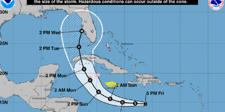
Florida Governor Ron DeSantis issued a State of Emergency this afternoon for 24 counties that are in the path of Tropical Depression 9, which includes Indian River County and Brevard County. The declaration will make available federal resources and support.
About an hour after the declaration, the storm’s path shifted slightly to the west, revealing potential landfall on the west coast of Florida and a track that continues north. However, it’s too early to predict where the potential hurricane will hit in Florida. Forecasters at the National Hurricane Center (NHC) predict a Category 3 just south of Tampa.
All weather models tracking the storm are inconsistent on where the hurricane will go. Right now, it’s a tropical depression that is trying to organize, so the tracking is expected to change again.
According to the latest tracking, we could feel tropical-force winds in Sebastian by Tuesday. But again, we want to emphasize that the tracking is expected to change again this weekend.
The NHC said the global models had shifted westward, but there is still uncertainty as it emerges into the southeastern Gulf of Mexico. Forecasters at NHC agree that atmospheric and oceanic conditions appear “very conducive for strengthening through early next week.”
“The very warm waters of the southeastern Gulf of Mexico should allow for more strengthening once it crosses Cuba, and the NHC forecast once again shows the system approaching the Florida peninsula as a major hurricane by the middle of next week.”
A hurricane watch has been issued for the Cayman Islands, and a tropical storm watch has been issued for Jamaica.
Sebastian Daily will keep you updated on any threats to our local area.


