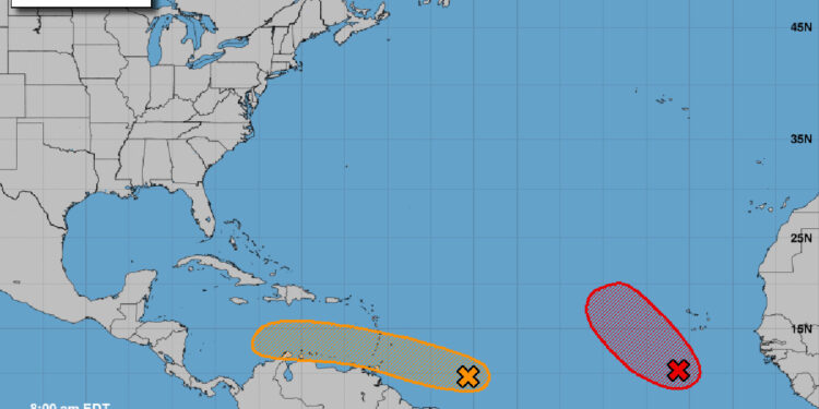
There’s another potential tropical depression moving in a similar path of Hurricane Ian as it travels westward at 15 to 20 mph, reaching the Windward Islands and the eastern Caribbean Sea by midweek.
However, the National Hurricane Center (NHC) says there’s only a 40 percent chance of the storm developing during the next five days. Ian had a 70 to 90 percent chance of further development when it was on the same track.
The tropical wave is located several hundred miles east of the southern Windward Islands, and it’s become better organized since yesterday.
“Some further development of the wave is possible, and a tropical depression could form within the next few days while it moves generally westward at 15 to 20 mph,” NHC said in a statement.
So far, based on the track provided by the NHC, the storm will move from the Atlantic into the Caribbean Sea and could continue west into Mexico. However, this is an early prediction, so it’s too soon to determine if the tropical depression will make a northern turn, as we watched Ian do last week.
Environmental conditions may keep the storm to the south as it continues west. It’s too soon to run weather models on where it could land.
At this time, there is no threat of a tropical storm or hurricane to Sebastian or Florida. However, if there is one, Sebastian Daily will keep you updated.
Hurricane Ian hit the west coast, impacting areas of Pine Island, Fort Myers, and Naples last week. The storm then moved through Brevard County.
The City of Sebastian never had sustainable winds greater than 40 to 45 mph, but the storm did cause some area flooding and wind damage to yards and some homes.
So far, the 2022 Atlantic Hurricane Season has had fewer storms than NOAA’s above-average Atlantic Hurricane Season prediction. The 2020 hurricane season was the most active on record.
Sebastian Daily will keep you updated.


