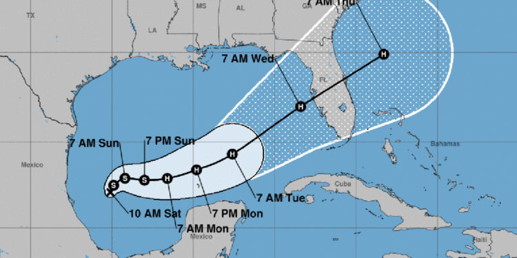
Tropical Depression Fourteen has formed in the Gulf of Mexico and is expected to impact Florida’s west coast this week, according to the National Hurricane Center (NHC).
“The intensification is likely to be slower during the next 12 to 24 hours until an inner core can become established, but after that time a faster rate of strengthening is anticipated,” NHC said.
The official NHC forecast shows the system nearing major hurricane strength over the central and eastern Gulf of Mexico.
“Regardless of the exact details of the intensity forecast, an intense hurricane with multiple life-threatening hazards is likely to affect the west coast of the Florida Peninsula next week,” NHC added.
Sebastian is currently in the projected path of this tropical system, with rainfall expected to begin on Sunday and continue through Wednesday. While the storm is expected to make landfall on the west coast, if it intensifies to a major hurricane, it could impact the entire Central Florida region, including Sebastian.
The track could change, but residents are urged to closely monitor this developing storm.
Here’s a brief overview of the forecast:
- Sunday: Mostly cloudy with a 50% chance of showers and thunderstorms. High near 85. East wind 10-20 mph.
- Monday: Showers likely, with thunderstorms possible. Mostly cloudy, high near 83. East wind 10-20 mph. Chance of rain 70%.
- Tuesday – Thursday: Storm is expected to pass over Florida.
There are no storm watches or warnings at this time.
Stay tuned to Sebastian Daily for continued updates on our local area. We’re also on Facebook and YouTube.


