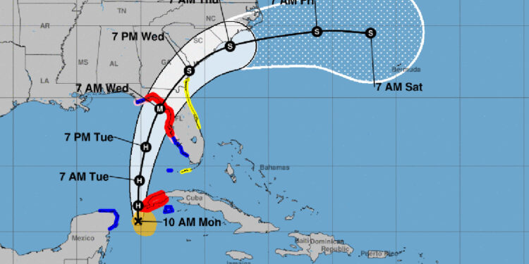
Tropical Storm Idalia is advancing northwards in the Gulf of Mexico, leading to storm surge and hurricane warnings for some areas on Florida’s western coastline. It’s predicted that Idalia will intensify into a major hurricane before reaching the northern parts of Florida’s west coast.
Additionally, there’s a tropical storm watch stretching from Georgia to the Sebastian Inlet. Despite this, Sebastian, Florida isn’t expected to face any direct hurricane or tropical storm threats. The National Hurricane Center (NHC) projects a high likelihood of thunderstorms and rain showers in the region. We’ll provide updates should there be any changes.
To clarify, a Tropical Storm Watch implies that conditions conducive to a tropical storm could arise in the designated area, typically within the next 48 hours.
Currently, Idalia is traveling north at a speed of about 8 mph, boasting maximum winds of 65 mph. Projections suggest that the storm will escalate to hurricane status by the end of today, evolving into a severe hurricane in the northeastern part of the Gulf of Mexico by early Wednesday.
Current forecasts anticipate the storm making landfall around the vicinity of Alligator Point and St. Mark’s Lighthouse, located slightly south of Tallahassee.


