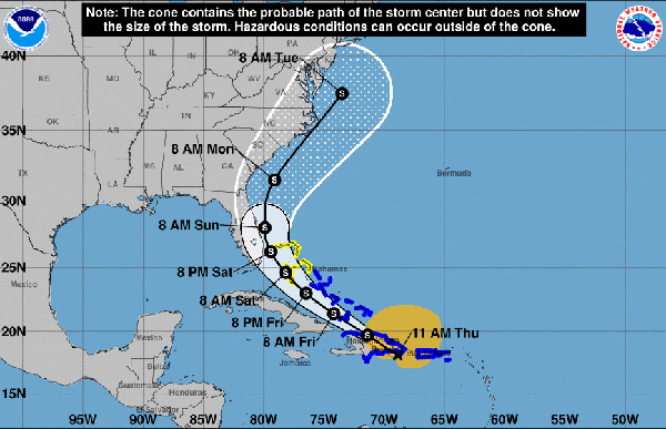
Tropical Storm Isaias will pass near Sebastian on Sunday morning, and we will get a lot of winds and rain. The good news is, this should remain a tropical storm and is not a hurricane unless the National Hurricane Center (NHC) says otherwise.
“The intensity forecast remains challenging. The structure of the storm is likely to be disrupted by its passage near or over Hispaniola today, and some weakening is likely. Once the system moves away from the Greater Antilles gradual strengthening is anticipated,” the NHC said in a statement.
It is possible that a new center will re-form as the system interacts with high terrain of that island later today or tonight, which shows instability.
A high pressure ridge over the western Atlantic should steer Isaias on a west-northwestward to northwestward heading over the next couple of days, but the likelihood of a center re-formation during the next 12-18 hours means that some adjustments to the track and motion are possible.
During the next 24 hours, the tracking and the strength of the storm could change. Forecasters are monitoring this storm closely as it aims for Florida.
If Sebastian gets a direct hit from Tropical Storm Isaias, we can expect maximum sustained winds of about 70 mph. These are not hurricane force winds. It’s important to pick up any debris in your yard and make storm preparations.
Mandatory evacuations are unlikely, but we are monitoring the emergency services for Brevard County and Indian River County just in case. Again, this storm has a lot of uncertainty at this time.
Sebastian Daily will continue to provide updates.


