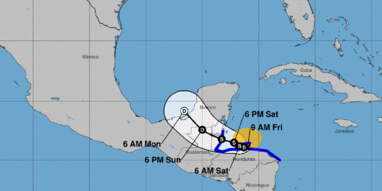
Despite recent discussions about a potential hurricane threat to Florida this week, the National Hurricane Center predicts Tropical Storm Sara will lose strength.
“After moving into the Yucatan, Sara is expected to quickly weaken, and what remains of the system when it emerges into the Bay of Campeche in the Gulf of Mexico is not very favorable for redevelopment,” NHC said.
Sara is gradually diminishing in strength as it moves through the waters between the Bay Islands and the Honduran mainland. Unfortunately, this storm has already brought catastrophic flooding and mudslides to several regions of Central America.
As of now, the tropical storm is maintaining maximum sustained winds of 50 miles per hour. Forecasters predict the storm could experience some slight intensification over the weekend, provided it continues its current track offshore of the Honduran coast. However, Sara is then expected to weaken and dissipate as it moves towards Florida.
As the remnants of Sara dissipate over the Gulf of Mexico, Florida could get periods of rain and thunderstorms along the Gulf Coast. The exact impacts will vary by location.
Cold Front for Sebastian
A cold front is moving through Sebastian, leading to a local flood advisory remaining in effect until 10 p.m. on Saturday. As the front passes, we can expect substantial cooling, with much lower temperatures settling in overnight.
Friday: Expect a mostly sunny day with a high near 79 degrees. As a cold front sweeps through, temperatures will dip to around 72 degrees in the evening. North winds will pick up, reaching 10-15 mph with gusts up to 25 mph. Overnight low, around 66 degrees.
Saturday and Sunday: Sunny skies and cooler temperatures continue, with highs near 78 degrees. Northeast winds will blow at 10-15 mph, gusting to 20 mph. No rain is expected.


